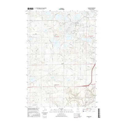
2016 Map of Victoria
USGS Topo · Published 2016About this map
Victoria serves as a focal point in this 2016 survey, where the town's expansion is evident amidst a landscape defined by an intricate network of glacial lakes and small water bodies. The terrain is dotted with significant local landmarks including the Saint Victoria Cem and Moravian Cem, indicating the area's deep-rooted community history. To the south, the settlement of Augusta sits near the winding course of Carver Cr, while the larger settlement of Carver marks the southeastern corner of the map. This area is characterized by its transition from agricultural heritage to suburban residential development, visible in the numerous named drives and residential clusters like those surrounding Stieger Lake and Lake Bavaria. Genealogists and local historians will find value in the specific placement of rural burial grounds such as the German Reformed Cem and Preiss Cem, which remain as markers of earlier settlement patterns before the modern road networks of Island View Rd and Dahlgren Rd were fully established.
Find a feature on this map
108 named features on this map. Tap any name to fly to it.
Don’t see what you’re looking for? This feature index may not catch every label — zoom into the map to look around manually.
Map Details
Editions of this 2016 Victoria Map
This is the sole edition of this map. No revisions or reprints were ever made.
Other maps of this area

1905 · Minnetonka
USGS Topo · 1:62,500

1907 · Minnetonka
USGS Topo · 1:62,500

1953 · Saint Paul
USGS Topo · 1:250,000

1957 · Belle Plaine
USGS Topo · 1:62,500

1957 · Waconia
USGS Topo · 1:62,500

1957 · New Prague
USGS Topo · 1:62,500

1958 · Victoria
USGS Topo · 1:24,000

1958 · Mound
USGS Topo · 1:24,000

1958 · Lake Minnetonka
USGS Topo · 1:62,500
1958 · Shakopee
USGS Topo · 1:24,000