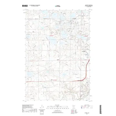
2019 Map of Victoria
USGS Topo · Published 2019About this map
Victoria and Chaska serve as the primary hubs in this late-2010s landscape where expanding suburban developments meet the established agricultural and lacustrine geography of Carver County. The map provides significant genealogical value through its detailed labeling of numerous burial sites, including the Lake Auburn Moravian Cem and the German Reformed Cem. A dense network of water bodies such as Wassermann Lake, Lake Bavaria, and Stieger Lake illustrates the glaciated terrain that has long defined local land use and recreation. Aviation history is noted at the Molnau Airpark, while the small settlement of Augusta remains a distinct waypoint. The transition from older township boundaries to modern thoroughfares like Arboretum Blvd and Victoria Dr shows how the region has modernized while retaining its rural roots.
Find a feature on this map
146 named features on this map. Tap any name to fly to it.
Don’t see what you’re looking for? This feature index may not catch every label — zoom into the map to look around manually.
Map Details
Editions of this 2019 Victoria Map
This is the sole edition of this map. No revisions or reprints were ever made.
Other maps of this area

1905 · Minnetonka
USGS Topo · 1:62,500

1907 · Minnetonka
USGS Topo · 1:62,500

1953 · Saint Paul
USGS Topo · 1:250,000

1957 · Belle Plaine
USGS Topo · 1:62,500

1957 · Waconia
USGS Topo · 1:62,500

1957 · New Prague
USGS Topo · 1:62,500

1958 · Victoria
USGS Topo · 1:24,000

1958 · Mound
USGS Topo · 1:24,000

1958 · Lake Minnetonka
USGS Topo · 1:62,500
1958 · Shakopee
USGS Topo · 1:24,000