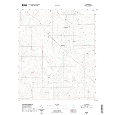
2020 Map of Vida
USGS Topo · Published 2020About this map
The low-lying wetlands of Swift Cr and Little Mulberry Cr define the landscape of north-central Autauga County, where small rural communities like Vida and Independence are centered around local churches and ancestral burial grounds. This modern topography reveals a distribution of family-named cemeteries such as Jones Cem, Golson Cem, and Deramus Cem, providing a clear record of local lineage across the township lines of T19N and T18N. The road network, including Perry Hills Hog Parlor Rd and Autauga Co 40, links these settlements with the eastern edge of Joffre. Researchers will find a concentrated cluster of history at the Friendship Missionary Baptist Church Cem and the nearby Bethesda Baptist Cem, where the surrounding Mill Cr and Sand Br once influenced the early development and agricultural boundaries of the region.
Find a feature on this map
64 named features on this map. Tap any name to fly to it.
Don’t see what you’re looking for? This feature index may not catch every label — zoom into the map to look around manually.
Map Details
Editions of this 2020 Vida Map
This is the sole edition of this map. No revisions or reprints were ever made.
Other maps of this area

1891 · Clanton
USGS Topo · 1:125,000

1953 · Montgomery
USGS Topo · 1:250,000

1956 · Montgomery
USGS Topo · 1:250,000

1957 · Montgomery
USGS Topo · 1:250,000

1957 · Autaugaville
USGS Topo · 1:62,500

1957 · Benton
USGS Topo · 1:62,500

1959 · Plantersville
USGS Topo · 1:62,500

1959 · Billingsley
USGS Topo · 1:62,500

1975 · Plantersville SE
USGS Topo · 1:24,000
1975 · Benton NE
USGS Topo · 1:24,000