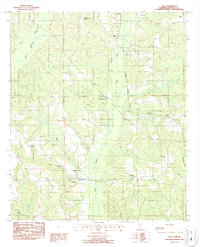
1987 Map of Vida
USGS Topo · Published 1987About this map
Illinois Central Gulf rail lines and a network of creeks define the rural landscape of Autauga County in this 1987 provisional survey. The settlement of Vida serves as a central point, with Vida Junction and Haynes to the north and Joffre to the east. The map captures a moment when traditional community landmarks—such as Big Springs Ch, Bethesda Ch, and Peace Ch—still anchored the social geography of the area. For genealogists, several family-named burial sites are recorded, including Jones Cem and Carter Cem. The presence of a major Pipeline and 2 Gas Pipelines running through the drainage basins of Swift Creek and Little Mulberry Creek illustrates the integration of modern infrastructure into this agricultural and wooded terrain.
Find a feature on this map
22 named features on this map. Tap any name to fly to it.
Don’t see what you’re looking for? This feature index may not catch every label — zoom into the map to look around manually.
Map Details
Editions of this 1987 Vida Map
This is the sole edition of this map. No revisions or reprints were ever made.
Other maps of this area

1891 · Clanton
USGS Topo · 1:125,000

1953 · Montgomery
USGS Topo · 1:250,000

1956 · Montgomery
USGS Topo · 1:250,000

1957 · Montgomery
USGS Topo · 1:250,000

1957 · Autaugaville
USGS Topo · 1:62,500

1957 · Benton
USGS Topo · 1:62,500

1959 · Plantersville
USGS Topo · 1:62,500

1959 · Billingsley
USGS Topo · 1:62,500

1975 · Plantersville SE
USGS Topo · 1:24,000
1975 · Benton NE
USGS Topo · 1:24,000