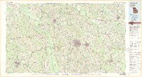
1979 Map of Vidalia
USGS Topo · Published 1980About this map
The Oconee River and Ohoopee River drain this portion of the Georgia coastal plain, where agriculture and the timber industry have long shaped the landscape. Centered on the growing city of Vidalia, the map captures a network of rural communities and vital transport lines, including the Seaboard Coast Line and Southern railroads that supported the region's agricultural exports. To the south, the confluence forming the Altamaha River defines the terrain, while landmarks like Brewton-Parker College in Mount Vernon and Gordonia Alatamaha State Park near Lyons indicate the cultural and recreational hubs of the late 1970s. This survey records a moment when many smaller settlements like Charlotteville, Alston, and Tarrytown remained distinct along the backroads connecting the larger county seats of Soperton, Metter, and Reidsville.
Find a feature on this map
102 named features on this map. Tap any name to fly to it.
Don’t see what you’re looking for? This feature index may not catch every label — zoom into the map to look around manually.
Map Details
Editions of this 1979 Vidalia Map
2 editions found
Other maps of this area

1919 · Claxton
USGS Topo · 1:62,500

1920 · Statesboro
USGS Topo · 1:62,500

1920 · Glennville
USGS Topo · 1:62,500

1921 · Rocky Ford
USGS Topo · 1:62,500

1943 · Rocky Ford
USGS Topo · 1:62,500

1943 · Millen
USGS Topo · 1:125,000

1943 · Statesboro
USGS Topo · 1:62,500

1944 · Claxton
USGS Topo · 1:62,500

1944 · Glennville
USGS Topo · 1:62,500

1946 · Brunswick
USGS Topo · 1:250,000