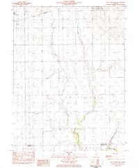
1982 Map of Villa Grove NW
USGS Topo · Published 1983About this map
The Embarras River meanders through this agricultural section of East Central Illinois, defining the rural landscape of southern Champaign and northern Douglas Counties. The survey captures the transport and community hubs of Philo and Tolono during the early 1980s, where the Norfolk and Western railroad corridor remains a primary artery for the region's grain-driven economy. Local heritage is preserved through markers such as the Jessee Cem and the Townhall within Crittenden township, reflecting the decentralized social structure of these farming townships. Educational and religious life is anchored by St Mary Sch and Unity High Sch, while a network of drainage features like Black Slough and Missouri Slough underscores the ongoing engineering required to manage the fertile but low-lying prairie land for cultivation.
Find a feature on this map
21 named features on this map. Tap any name to fly to it.
Don’t see what you’re looking for? This feature index may not catch every label — zoom into the map to look around manually.
Map Details
Editions of this 1982 Villa Grove NW Map
This is the sole edition of this map. No revisions or reprints were ever made.
Other maps of this area

1906 · Urbana
USGS Topo · 1:62,500

1907 · Mahomet
USGS Topo · 1:62,500

1950 · Tuscola
USGS Topo · 1:62,500

1956 · Villa Grove
USGS Topo · 1:62,500

1957 · Urbana
USGS Topo · 1:62,500

1957 · Urbana
USGS Topo · 1:24,000

1957 · Mahomet
USGS Topo · 1:62,500

1957 · Bondville
USGS Topo · 1:24,000

1958 · Peoria
USGS Topo · 1:250,000

1958 · Decatur
USGS Topo · 1:250,000