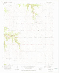
1972 Map of Villegreen
USGS Topo · Published 1975About this map
Villegreen sits at the heart of this high plains landscape in Las Animas County, where the topography is defined by the erosion of the Seven Pocket plateau into deep drainages. The mapping reveals a sparse but deliberate settlement pattern characteristic of the region's ranching history, with numerous fence lines and wells scattered across the terrain. Water sources are critical here, as evidenced by the labeling of multiple Springs and the descent of Plum Canyon Creek and Poitrey Creek toward lower elevations.
Find a feature on this map
15 named features on this map. Tap any name to fly to it.
Don’t see what you’re looking for? This feature index may not catch every label — zoom into the map to look around manually.
Map Details
Editions of this 1972 Villegreen Map
4 editions found
Other maps of this area

1891 · Mesa De Maya
USGS Topo · 1:125,000

1892 · Mt Carrizo
USGS Topo · 1:125,000

1893 · Mesa de Maya
USGS Topo · 1:125,000

1955 · La Junta
USGS Topo · 1:250,000

1958 · La Junta
USGS Topo · 1:250,000

1968 · La Junta
USGS Topo · 1:250,000

1972 · Johnson Canyon
USGS Topo · 1:24,000

1972 · Miners Peak
USGS Topo · 1:24,000

1972 · Plum Canyon
USGS Topo · 1:24,000

1972 · Tobe
USGS Topo · 1:24,000