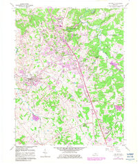
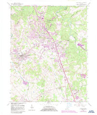
1960 Map of Vine Grove
USGS Topo · Published 1983About this map
Fort Knox Military Reservation dominates the northeastern landscape of this survey, illustrating the significant federal footprint in Hardin Co during the early 1960s. The map reveals the postwar expansion of Radcliff and Vine Grove Junction, where a new Drive-in Theater and housing developments like Dietz Acres began to replace traditional farmland. To the south, the older community of Vine Grove remains a hub for the surrounding rural area, centered on the Illinois Central Gulf railroad line. The document is an essential resource for tracing local genealogy, featuring numerous family and community sites such as Lincoln Memorial Cem, Stovall Ch, and the Rogersville Sch. The terrain is characterized by the winding path of Otter Creek and its many tributaries, including Brushy Fork and Gander Branch, which define the natural boundaries between the military reservation and private lands.
Find a feature on this map
42 named features on this map. Tap any name to fly to it.
Don’t see what you’re looking for? This feature index may not catch every label — zoom into the map to look around manually.
Map Details
Editions of this 1960 Vine Grove Map
5 editions found
Other maps of this area

1932 · Big Clifty
USGS Topo · 1:62,500

1935 · Elizabethtown
USGS Topo · 1:48,000

1936 · Vine Grove
USGS Topo · 1:62,500

1938 · Elizabethtown
USGS Topo · 1:62,500

1941 · Ekron
USGS Topo · 1:62,500

1943 · Vine Grove
USGS Topo · 1:62,500

1946 · Rock Haven
USGS Topo · 1:24,000

1946 · Pitts Point
USGS Topo · 1:24,000

1946 · Fort Knox
USGS Topo · 1:24,000

1946 · Colesburg
USGS Topo · 1:24,000