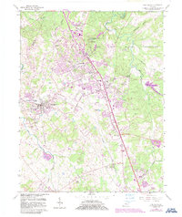
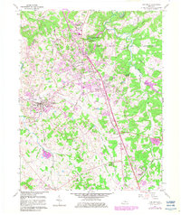
1960 Map of Vine Grove
USGS Topo · Published 1987About this map
The Fort Knox Military Reservation dominates the northeastern portion of this landscape, its boundary following the winding course of Mill Creek and Buffalo Branch. South of the military installation, the post-war growth of Radcliff and Vine Grove is evident, with suburban developments like Dietz Acres appearing alongside the Louisville and Nashville railroad corridor. The mapping reveals a transition from these expanding settlements to the more rural character of Rineyville in the south, where the Illinois Central railroad cuts through the terrain near Pawley Creek.
Find a feature on this map
50 named features on this map. Tap any name to fly to it.
Don’t see what you’re looking for? This feature index may not catch every label — zoom into the map to look around manually.
Map Details
Editions of this 1960 Vine Grove Map
5 editions found
Other maps of this area

1932 · Big Clifty
USGS Topo · 1:62,500

1935 · Elizabethtown
USGS Topo · 1:48,000

1936 · Vine Grove
USGS Topo · 1:62,500

1938 · Elizabethtown
USGS Topo · 1:62,500

1941 · Ekron
USGS Topo · 1:62,500

1943 · Vine Grove
USGS Topo · 1:62,500

1946 · Rock Haven
USGS Topo · 1:24,000

1946 · Pitts Point
USGS Topo · 1:24,000

1946 · Fort Knox
USGS Topo · 1:24,000

1946 · Colesburg
USGS Topo · 1:24,000