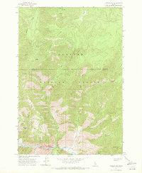
1962 Map of Vinegar Hill
USGS Topo · Published 1972About this map
Payette National Forest dominates this interior landscape, where the Idaho Co Valley Co boundary line follows high ridges and drainage divides. The topography is defined by the sharp descent from peaks like Cold Mtn and Horse Mtn down to the fundamental waterway of Big Creek. This 1962 field-checked survey highlights the critical role of aviation in this backcountry, marking isolated access points at the Vines Landing Strip and the Cabin Creek Landing Strip. Local geography is further detailed by named basins and saddles, including Townhead Basin and Blackburn Saddle, which provided key navigational waypoints before modern road development. The drainage network is particularly intricate here, with the Crooked Fork Creek and Cabin Creek carving deep paths through the Cold Mountain Ridge.
Find a feature on this map
24 named features on this map. Tap any name to fly to it.
Don’t see what you’re looking for? This feature index may not catch every label — zoom into the map to look around manually.
Map Details
Editions of this 1962 Vinegar Hill Map
3 editions found
Other maps of this area

1956 · Elk City
USGS Topo · 1:250,000

1960 · Elk City
USGS Topo · 1:250,000

1962 · Mormon Mtn
USGS Topo · 1:24,000

1962 · Vinegar Hill
USGS Topo · 1:24,000

1962 · Papoose Peak
USGS Topo · 1:24,000

1962 · Dave Lewis Peak
USGS Topo · 1:24,000

1973 · Acorn Butte
USGS Topo · 1:24,000
1973 · Monument
USGS Topo · 1:24,000

1977 · Cottonwood Butte
USGS Topo · 1:24,000

1978 · Wapiti Creek
USGS Topo · 1:24,000