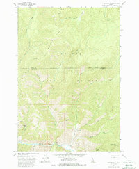
1962 Map of Vinegar Hill
USGS Topo · Published 1987About this map
Payette National Forest dominates this wilderness landscape along the border of Idaho and Valley Counties. The 1962 survey reveals a remote backcountry accessible primarily by water and air, evidenced by the distribution of remote airfields like Vines Landing Strip, Cabin Creek Landing Strip, and Miles Landing Strip. High-elevation landmarks such as Cold Mtn and Vinegar Hill define the steep topography, while Big Creek serves as the primary drainage through the southern portion of the sheet. Notable for its lack of established road networks, the area relies on historic crossings like Caswell Crossing and a system of creek forks, including Crooked Fork Creek and South Fork Cottonwood Creek. Small basins such as Towhead Basin and Browns Basin provide natural clearings within the dense forest, offering a clear view of the mid-century wilderness before modern development or recreation expanded in the region.
Find a feature on this map
31 named features on this map. Tap any name to fly to it.
Don’t see what you’re looking for? This feature index may not catch every label — zoom into the map to look around manually.
Map Details
Editions of this 1962 Vinegar Hill Map
3 editions found
Other maps of this area

1956 · Elk City
USGS Topo · 1:250,000

1960 · Elk City
USGS Topo · 1:250,000

1962 · Mormon Mtn
USGS Topo · 1:24,000

1962 · Vinegar Hill
USGS Topo · 1:24,000

1962 · Papoose Peak
USGS Topo · 1:24,000

1962 · Dave Lewis Peak
USGS Topo · 1:24,000

1973 · Acorn Butte
USGS Topo · 1:24,000
1973 · Monument
USGS Topo · 1:24,000

1977 · Cottonwood Butte
USGS Topo · 1:24,000

1978 · Wapiti Creek
USGS Topo · 1:24,000