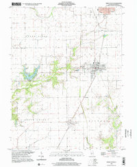
1998 Map of Virden South
USGS Topo · Published 2002About this map
Girard and the southern edge of Virden anchor this Macoupin County landscape during the late 1990s. The region is defined by a traditional Midwestern grid of agricultural fields and small townships, including North Otter, South Otter, and Nilwood. To the west, the landscape shifts as Otter Creek and its East Fork feed into the man-made Sunset Lake, a significant local water feature marked by its Intake and spillway.
Find a feature on this map
28 named features on this map. Tap any name to fly to it.
Don’t see what you’re looking for? This feature index may not catch every label — zoom into the map to look around manually.
Map Details
Editions of this 1998 Virden South Map
This is the sole edition of this map. No revisions or reprints were ever made.
Other maps of this area

1922 · Divernon
USGS Topo · 1:62,500

1923 · Carlinville
USGS Topo · 1:48,000

1923 · Raymond
USGS Topo · 1:62,500

1924 · Divernon
USGS Topo · 1:62,500

1924 · Waverly
USGS Topo · 1:62,500

1925 · Carlinville
USGS Topo · 1:62,500

1925 · Raymond
USGS Topo · 1:62,500

1926 · Waverly
USGS Topo · 1:62,500

1931 · Carlinville
USGS Topo · 1:62,500

1958 · Decatur
USGS Topo · 1:250,000