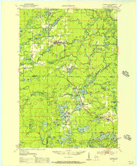
1951 Map of Wabeno
USGS Topo · Published 1956About this map
Wabeno and neighboring Soperton serve as the primary hubs in this timber-dense landscape, situated along the Chicago and North Western rail line. The map highlights the early 1950s development of the Nicolet National Forest, revealing a complex network of forest roads and conservation infrastructure, such as the Carter Lookout Tower and Archibald Tower Lookout Tower. Settlement patterns are closely tied to the surrounding water, with numerous small communities and schools like Rummel Sch and Windfall Sch serving rural families. Cultural landmarks, including the Indian Community Hall and several local burial grounds like Roseland Cem and Lakeside Cem, provide essential data points for local history. The abundance of named water bodies, from Trump Lake to Reservoir Pond, underscores the region's character as a destination for outdoor recreation and resource management during the mid-century era.
Find a feature on this map
112 named features on this map. Tap any name to fly to it.
Don’t see what you’re looking for? This feature index may not catch every label — zoom into the map to look around manually.
Map Details
Editions of this 1951 Wabeno Map
3 editions found

Other maps of this area

1939 · Crandon
USGS Topo · 1:48,000

1939 · Goodman
USGS Topo · 1:48,000

1939 · Laona
USGS Topo · 1:48,000

1940 · Thunder Mtn.
USGS Topo · 1:48,000

1941 · Crandon
USGS Topo · 1:48,000

1942 · Breed
USGS Topo · 1:48,000

1942 · Wabeno
USGS Topo · 1:48,000

1942 · Pearson
USGS Topo · 1:48,000

1946 · Laona
USGS Topo · 1:48,000

1946 · Goodman
USGS Topo · 1:48,000