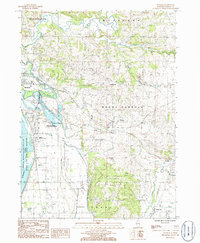
1985 Map of Wacker
USGS Topo · Published 1986About this map
The Plum River and Carroll Creek converge amidst the dissected uplands of Carroll County in this mid-1980s topographic study. The landscape is defined by the sharp transition from the bluffs to the bottomlands of the Mississippi River, where the Upper Mississippi River Wild Life and Fish Refuge buffers the eastern bank. Small rural communities like Wacker, Argo Fay, and Center Hill anchor the interior, while the eastern edge of Savanna appears along the river. Resource extraction is evident through scattered industrial sites including a Quarry and Actual Sand Pit. Specialized land use is noted at the Stransky Memorial Airport and the Ayers Sand Prairie State Nature Preserve, highlighting a mix of regional transport and ecological conservation. Local history is reflected in landmarks like Old Mill Park, suggesting the area's agricultural and milling heritage along the winding creeks.
Find a feature on this map
25 named features on this map. Tap any name to fly to it.
Don’t see what you’re looking for? This feature index may not catch every label — zoom into the map to look around manually.
Map Details
Editions of this 1985 Wacker Map
This is the sole edition of this map. No revisions or reprints were ever made.
Other maps of this area

1891 · Clinton
USGS Topo · 1:62,500

1892 · Savanna
USGS Topo · 1:62,500

1894 · Clinton
USGS Topo · 1:62,500

1899 · Clinton
USGS Topo · 1:125,000

1934 · Morrison
USGS Topo · 1:48,000

1940 · Morrison
USGS Topo · 1:62,500

1942 · Mt Carroll
USGS Topo · 1:62,500

1944 · Mt Carroll
USGS Topo · 1:62,500

1952 · Clinton
USGS Topo · 1:62,500

1952 · Savanna
USGS Topo · 1:62,500