
1960 Map of Waco
USGS Topo · Published 1962About this map
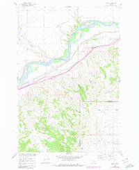
The Yellowstone River cuts a wide, braided path through this 1960 survey, defining the transition between the broad alluvial Sevenmile Flat to the north and the intricate drainage networks of the south. The settlement of Waco and the rail stop at Fee anchor the transportation corridor, where the Northern Pacific railroad tracks parallel the river's course. This infrastructure supported a ranching economy that extended deep into the hills, marked by family operations like the Kemph Ranch near the boundary of Yellowstone and Big Horn Counties.
Find a feature on this map
24 named features on this map. Tap any name to fly to it.
Don’t see what you’re looking for? This feature index may not catch every label — zoom into the map to look around manually.
Map Details
Editions of this 1960 Waco Map
2 editions found
Other maps of this area

1894 · Fort Custer
USGS Topo · 1:125,000

1954 · Hardin
USGS Topo · 1:250,000

1954 · Forsyth
USGS Topo · 1:250,000

1957 · Hardin
USGS Topo · 1:250,000

1957 · Forsyth
USGS Topo · 1:250,000

1958 · Forsyth
USGS Topo · 1:250,000

1958 · Hardin
USGS Topo · 1:250,000

1960 · Foster
USGS Topo · 1:24,000

1960 · Coal Bank Creek
USGS Topo · 1:24,000

1960 · Custer
USGS Topo · 1:24,000