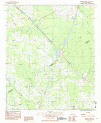
1982 Map of Wadboo Swamp
USGS Topo · Published 1983About this map
Four Hole Swamp and Wadboo Swamp dominate this Lowcountry landscape along the border of Orangeburg and Dorchester Counties as it was documented in the mid-1970s. The area's social fabric is anchored by rural congregations at Ebenezer Ch, St Stephens Ch, and The Second Providence Ch, reflecting the deep-seated community hubs typical of South Carolina's inland coastal plain. Near the settlement of Rosinville, the map reveals a network of watercourses including Cow Castle Creek and Indian Field Swamp, which historically dictated the pattern of local travel and agriculture.
Find a feature on this map
19 named features on this map. Tap any name to fly to it.
Don’t see what you’re looking for? This feature index may not catch every label — zoom into the map to look around manually.
Map Details
Editions of this 1982 Wadboo Swamp Map
This is the sole edition of this map. No revisions or reprints were ever made.
Other maps of this area

1919 · Ridgeville
USGS Topo · 1:48,000

1920 · Eutawville
USGS Topo · 1:48,000

1920 · Bowman
USGS Topo · 1:48,000

1920 · Ridgeville
USGS Topo · 1:62,500

1920 · St. George
USGS Topo · 1:48,000

1921 · Bowman
USGS Topo · 1:62,500

1921 · St. George
USGS Topo · 1:62,500

1921 · Eutawville
USGS Topo · 1:62,500

1943 · Bowman
USGS Topo · 1:62,500

1943 · Orangeburg
USGS Topo · 1:125,000