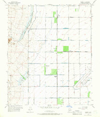
1957 Map of Waddell
USGS Topo · Published 1968About this map
Waddell and its surrounding citrus groves anchor this mid-century view of the Salt River Valley's western edge. The landscape is a study in organized irrigation and flood control, dominated by a massive Detention Basin and Levee system designed to manage the seasonal flows of Trilby Wash before they reach the valley floor. To the east, the agricultural grid is defined by straight section-line roads like Waddell Avenue and Cotton Lane, supporting citrus production at Citrus Park and Citrus Park (Siding).
Find a feature on this map
36 named features on this map. Tap any name to fly to it.
Don’t see what you’re looking for? This feature index may not catch every label — zoom into the map to look around manually.
Map Details
Editions of this 1957 Waddell Map
4 editions found

Other maps of this area

1946 · Avondale
USGS Topo · 1:62,500

1948 · Cashion
USGS Topo · 1:62,500

1954 · Phoenix
USGS Topo · 1:250,000

1957 · Phoenix
USGS Topo · 1:250,000

1957 · White Tank Mts. SE
USGS Topo · 1:24,000

1957 · Valencia
USGS Topo · 1:24,000

1957 · Perryville
USGS Topo · 1:24,000

1957 · White Tank Mts. NE
USGS Topo · 1:24,000

1957 · Calderwood Butte
USGS Topo · 1:24,000

1957 · McMicken Dam
USGS Topo · 1:24,000