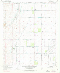
1957 Map of Waddell
USGS Topo · Published 1976About this map
The agricultural and military expansion of western Maricopa County is documented here during the late 1950s. The northwest corner of Luke Air Force Base dominates the lower right, positioned near the crossroads of the Atchison Topeka and Santa Fe railroad line. Small rural settlements and railroad sidings like Waddell, Fennemore, Wayne, and Citrus Park are plotted along a strictly gridded network of roads, including Olive Avenue and Peoria Avenue.
Find a feature on this map
38 named features on this map. Tap any name to fly to it.
Don’t see what you’re looking for? This feature index may not catch every label — zoom into the map to look around manually.
Map Details
Editions of this 1957 Waddell Map
4 editions found

Other maps of this area

1946 · Avondale
USGS Topo · 1:62,500

1948 · Cashion
USGS Topo · 1:62,500

1954 · Phoenix
USGS Topo · 1:250,000

1957 · Phoenix
USGS Topo · 1:250,000

1957 · White Tank Mts. SE
USGS Topo · 1:24,000

1957 · Valencia
USGS Topo · 1:24,000

1957 · Perryville
USGS Topo · 1:24,000

1957 · White Tank Mts. NE
USGS Topo · 1:24,000

1957 · Calderwood Butte
USGS Topo · 1:24,000

1957 · McMicken Dam
USGS Topo · 1:24,000