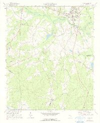
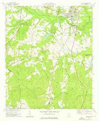
1973 Map of Wadley
USGS Topo · Published 1991About this map
The town of Wadley serves as the focal point of this coastal plain landscape, situated at the junction where the Central of Georgia railroad crosses the upper reaches of Williamson Swamp Creek. The settlement pattern in the early 1970s reflects a rural economy deeply tied to the creek systems, with numerous family-named churches and small schools scattered throughout the countryside. Places of worship such as Blounts Chapel Ch, Pinetucky Ch, and Spell Grove Ch indicate long-standing community centers across Jefferson Co, Emanuel Co, and Johnson Co. South of town, the terrain transitions into a more sparsely populated area defined by the drainage basins of Rocky Creek, Nails Creek, and Mill Creek, where a Lookout Tower and an Abandoned Railroad Grade mark the changing uses of the land.
Find a feature on this map
32 named features on this map. Tap any name to fly to it.
Don’t see what you’re looking for? This feature index may not catch every label — zoom into the map to look around manually.
Map Details
Editions of this 1973 Wadley Map
2 editions found
Other maps of this area

1957 · Macon
USGS Topo · 1:250,000

1958 · Macon
USGS Topo · 1:250,000

1964 · Macon
USGS Topo · 1:250,000

1971 · Dellwood
USGS Topo · 1:24,000

1971 · Summertown
USGS Topo · 1:24,000
1973 · Louisville South
USGS Topo · 1:24,000
1973 · Davisboro SE
USGS Topo · 1:24,000
1973 · Old Town
USGS Topo · 1:24,000

1973 · Colemans Lake
USGS Topo · 1:24,000
1973 · Wadley
USGS Topo · 1:24,000