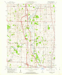
1960 Map of Wadsworth
USGS Topo · Published 1962About this map
The Des Plaines River corridor defines this 1960 landscape along the Illinois and Wisconsin border, where the newly constructed Tri-State Tollway cuts a modern path through established farming communities. The map captures the area before intensive suburban expansion, documenting the rural character of settlements like Rosecrans and Wadsworth. Local history is preserved in a network of family and community landmarks, including Mount Rest Cem, Oakdale Cem, and the St Patricks Cem near the junction of the Milwaukee St Paul and Pacific railroad. To the south, the early footprint of the Waukegan Airport sits near the developing edge of Waukegan and Gurnee. These details reveal a transitional era where traditional crossroads like Gurney Corners and Dillys Corners remained distinct amidst the emerging high-speed transit infrastructure of Lake County.
Find a feature on this map
59 named features on this map. Tap any name to fly to it.
Don’t see what you’re looking for? This feature index may not catch every label — zoom into the map to look around manually.
Map Details
Editions of this 1960 Wadsworth Map
3 editions found
Other maps of this area

1892 · Racine
USGS Topo · 1:62,500

1893 · Silver Lake
USGS Topo · 1:62,500

1905 · Racine
USGS Topo · 1:62,500

1906 · Silver Lake
USGS Topo · 1:62,500

1906 · Waukegan
USGS Topo · 1:62,500

1908 · Waukegan
USGS Topo · 1:62,500

1920 · Grays Lake
USGS Topo · 1:62,500

1923 · Grays Lake
USGS Topo · 1:62,500

1954 · Rockford
USGS Topo · 1:250,000

1955 · Rockford
USGS Topo · 1:250,000