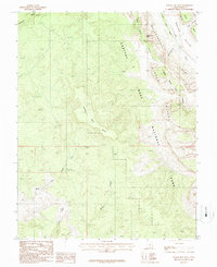
1987 Map of Wagon Box Mesa
USGS Topo · Published 1987About this map
Capitol Reef National Park and the striking geologic formation of the Waterpocket Fold dominate this eastern Garfield County landscape. Surveyed in the late 1980s, the map reveals a wilderness of high plateaus and deep drainage systems, most notably the central Wagon Box Mesa. The eastern edge of the quadrangle is defined by the steep descent of the Circle Cliffs, where narrow paths like Upper Muley Twist Canyon and Lower Muley Twist Canyon cut through the monocline. Water sources are scarce but critical, represented by the ephemeral Moody Creek and North Fork Silver Falls Creek. Distinctive landmarks such as Peek-a-boo Rock and the fossil-rich Oyster Shell Reef provide essential orientation points in this labyrinth of sandstone and sedimentary ridges.
Find a feature on this map
16 named features on this map. Tap any name to fly to it.
Don’t see what you’re looking for? This feature index may not catch every label — zoom into the map to look around manually.
Map Details
Editions of this 1987 Wagon Box Mesa Map
2 editions found
Other maps of this area

1886 · Escalante
USGS Topo · 1:250,000

1886 · Henry Mountains
USGS Topo · 1:250,000

1892 · Henry Mountains
USGS Topo · 1:250,000

1953 · Mt Pennell
USGS Topo · 1:62,500

1953 · Circle Cliffs 1 SE
USGS Topo · 1:24,000

1953 · Circle Cliffs 4 NW
USGS Topo · 1:24,000

1953 · Circle Cliffs 1 SW
USGS Topo · 1:24,000

1953 · Mt Pennell 3 NW
USGS Topo · 1:24,000
1953 · Circle Cliffs 1 NW
USGS Topo · 1:24,000
1953 · Circle Cliffs 1 NE
USGS Topo · 1:24,000