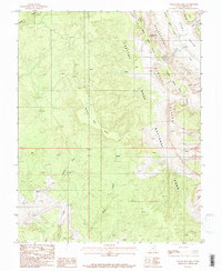
1987 Map of Wagon Box Mesa
USGS Topo · Published 1987About this map
Wagon Box Mesa dominates the central landscape of this Garfield County survey, illustrating the complex geology of the high desert before modern expansion. This 1987 provisional edition documents the dramatic uplift and erosion patterns within Capitol Reef National Park, where the towering Capitol Reef and Circle Cliffs define the region's verticality. The map captures the distinct geological alignment of the Waterpocket Fold, a massive monocline that dictates the drainage of seasonal waterways like Upper Muley Twist Canyon and Silver Falls Creek.
Find a feature on this map
17 named features on this map. Tap any name to fly to it.
Don’t see what you’re looking for? This feature index may not catch every label — zoom into the map to look around manually.
Map Details
Editions of this 1987 Wagon Box Mesa Map
2 editions found
Other maps of this area

1886 · Escalante
USGS Topo · 1:250,000

1886 · Henry Mountains
USGS Topo · 1:250,000

1892 · Henry Mountains
USGS Topo · 1:250,000

1953 · Mt Pennell
USGS Topo · 1:62,500

1953 · Circle Cliffs 1 SE
USGS Topo · 1:24,000

1953 · Circle Cliffs 4 NW
USGS Topo · 1:24,000

1953 · Circle Cliffs 1 SW
USGS Topo · 1:24,000

1953 · Mt Pennell 3 NW
USGS Topo · 1:24,000
1953 · Circle Cliffs 1 NW
USGS Topo · 1:24,000
1953 · Circle Cliffs 1 NE
USGS Topo · 1:24,000