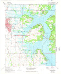
1974 Map of Wagoner East
USGS Topo · Published 1978About this map
Wagoner serves as the focal point for this mid-1970s survey, illustrating a community defined by its proximity to the expansive waters of Fort Gibson Lake. The eastern edge of town transitions into a landscape of recreation and conservation, featuring the State Waterfowl Refuge and the winding reaches of the Neosho River. A network of transportation is clearly visible, with the Missouri Kansas Texas Railroad and Missouri Pacific Railroad providing industrial backbone to the region. To the east, the map details the rising elevation of Blue Mound and the rugged shoreline near Sequoyah State Park. Local history is anchored by sites like Elmwood Cem, Pioneer Memorial Cem, and neighborhood anchors such as Maple Sch and Trinity Ch. The map also documents aviation facilities including Wagoner Airfield and the Rickelson Ranch Landing Strip, reflecting the varied land use of the era.
Find a feature on this map
46 named features on this map. Tap any name to fly to it.
Don’t see what you’re looking for? This feature index may not catch every label — zoom into the map to look around manually.
Map Details
Editions of this 1974 Wagoner East Map
This is the sole edition of this map. No revisions or reprints were ever made.
Other maps of this area

1896 · Pryor
USGS Topo · 1:125,000

1901 · Muscogee
USGS Topo · 1:125,000

1901 · Pryor
USGS Topo · 1:125,000

1905 · Muscogee
USGS Topo · 1:125,000

1946 · Fort Smith
USGS Topo · 1:250,000

1948 · Hulbert
USGS Topo · 1:62,500

1948 · Wagoner
USGS Topo · 1:62,500

1950 · Wagoner
USGS Topo · 1:62,500

1950 · Hulbert
USGS Topo · 1:62,500

1954 · Tulsa
USGS Topo · 1:250,000