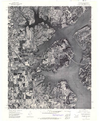
1972 Map of Wagoner NE
USGS Topo · Published 1974About this map
Fort Gibson Lake dominates the eastern half of this 1972 orthophotoquad, its winding shoreline and numerous inlets creating a complex aquatic boundary for the surrounding Oklahoma landscape. The orthophoto format, produced by the Usgs from high-altitude aerial imagery, provides a direct visual record of land use and vegetation patterns during the early 1970s. On the western edge, the outskirts of Wagoner are visible, showing the residential and commercial footprints of the community as it relates to the nearby water resources. The contrast between the organized street grids of the settlement and the irregular, flooded valleys of the lake illustrates the regional transformation following the impoundment of the Grand River, highlighting the transition from traditional agriculture to a landscape increasingly defined by recreation and water management.
Find a feature on this map
2 named features on this map. Tap any name to fly to it.
Don’t see what you’re looking for? This feature index may not catch every label — zoom into the map to look around manually.
Map Details
Editions of this 1972 Wagoner NE Map
This is the sole edition of this map. No revisions or reprints were ever made.
Other maps of this area

1896 · Pryor
USGS Topo · 1:125,000

1901 · Muscogee
USGS Topo · 1:125,000

1901 · Pryor
USGS Topo · 1:125,000

1905 · Muscogee
USGS Topo · 1:125,000

1946 · Fort Smith
USGS Topo · 1:250,000

1948 · Hulbert
USGS Topo · 1:62,500

1948 · Wagoner
USGS Topo · 1:62,500

1950 · Wagoner
USGS Topo · 1:62,500

1950 · Hulbert
USGS Topo · 1:62,500

1954 · Tulsa
USGS Topo · 1:250,000