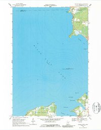
1968 Map of Wahkon North
USGS Topo · Published 1987About this map
Mille Lacs Lake dominates this 1960s survey, revealing the intricate bathymetry and shoreline development of the lake's southern and eastern reaches. Along the southern coast, the village of Wahkon sits at the edge of Wahkon Bay, serving as a gateway to the surrounding recreational and conservation lands. The map details the transition from the organized town blocks to the wooded interiors of South Harbor and Isle Harbor, where sites like the Galloway Youth Camp are established.
Find a feature on this map
27 named features on this map. Tap any name to fly to it.
Don’t see what you’re looking for? This feature index may not catch every label — zoom into the map to look around manually.
Map Details
Editions of this 1968 Wahkon North Map
2 editions found
Other maps of this area

1916 · Wealthwood
USGS Topo · 1:62,500

1953 · Duluth
USGS Topo · 1:250,000

1958 · Duluth
USGS Topo · 1:250,000

1968 · Onamia NW
USGS Topo · 1:24,000

1968 · Onamia
USGS Topo · 1:24,000

1968 · Isle SW
USGS Topo · 1:24,000

1968 · Wahkon North
USGS Topo · 1:24,000

1968 · Isle
USGS Topo · 1:24,000
1968 · Wahkon South
USGS Topo · 1:24,000

1969 · Thor SW
USGS Topo · 1:24,000
Featured Places
- Wahkon, MN
- South Harbor Township, MN
- Isle Harbor Township, MN
- East Side Township, MN
- Mille Lacs County, MN