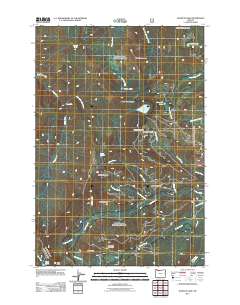
2011 Map of Wahtum Lake
USGS Topo · Published 2011About this map
Wahtum Lake serves as a central hydrological landmark in this high-elevation portion of the Cascades, where the headwaters of several significant drainage systems originate. The landscape is defined by a series of prominent peaks and ridges, including Chinidere Mountain, Tomlike Mountain, and Sawtooth Mountain, which separate the watersheds of Eagle Creek to the west and the West Fork Hood River to the east. This 2011 survey reveals a complex network of forest roads and trails that provide access to remote water bodies like Black Lake, Ottertail Lake, and Scout Lake. Notable landmarks for hikers and backcountry travelers include the site of Tunnel Falls and the named water sources at Indian Springs and Smokey Spring. The presence of features such as Four One Half Mile Bridge and the various named branches like Long Branch Creek and Lake Branch illustrate the intricate topographical grain of this protected forest environment.
Find a feature on this map
36 named features on this map. Tap any name to fly to it.
Don’t see what you’re looking for? This feature index may not catch every label — zoom into the map to look around manually.
Map Details
Editions of this 2011 Wahtum Lake Map
This is the sole edition of this map. No revisions or reprints were ever made.
Other maps of this area

1924 · Mount Hood
USGS Topo · 1:125,000

1926 · Hood River
USGS Topo · 1:125,000

1927 · Mount Hood
USGS Topo · 1:125,000

1929 · Hood River
USGS Topo · 1:125,000

1953 · The Dalles
USGS Topo · 1:250,000

1956 · The Dalles
USGS Topo · 1:250,000

1957 · The Dalles
USGS Topo · 1:250,000

1957 · Bonneville Dam
USGS Topo · 1:62,500

1957 · Hood River
USGS Topo · 1:62,500
1962 · Hickman Butte
USGS Topo · 1:24,000