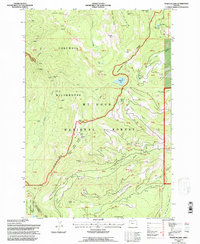
1994 Map of Wahtum Lake
USGS Topo · Published 1997About this map
Waucoma Ridge serves as the dominant spine of this landscape within the Mt Hood National Forest, where the high-altitude Wahtum Lake sits as a central landmark for backcountry travel. The map documents the mid-1990s configuration of the Pacific Crest National Scenic Trail as it winds past Chinidere Mtn and Indian Springs. This area is defined by its strict management boundaries, including the Bull Run Watershed Management Unit, which restricts access to the west. Evidence of seasonal use and forest recreation is found at sites like WyEast Camp, 7½ Mile Camp, and Noble Camp. The terrain drops sharply toward the Columbia Wilderness and the Eagle Creek drainage, characterized by numerous unnamed Falls and steep ridges such as Sawtooth Mountain.
Find a feature on this map
52 named features on this map. Tap any name to fly to it.
Don’t see what you’re looking for? This feature index may not catch every label — zoom into the map to look around manually.
Map Details
Editions of this 1994 Wahtum Lake Map
This is the sole edition of this map. No revisions or reprints were ever made.
Other maps of this area

1924 · Mount Hood
USGS Topo · 1:125,000

1926 · Hood River
USGS Topo · 1:125,000

1927 · Mount Hood
USGS Topo · 1:125,000

1929 · Hood River
USGS Topo · 1:125,000

1953 · The Dalles
USGS Topo · 1:250,000

1956 · The Dalles
USGS Topo · 1:250,000

1957 · The Dalles
USGS Topo · 1:250,000

1957 · Bonneville Dam
USGS Topo · 1:62,500

1957 · Hood River
USGS Topo · 1:62,500
1962 · Hickman Butte
USGS Topo · 1:24,000