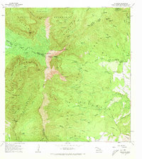
1965 Map of Waialeale
USGS Topo · Published 1973About this map
Waialeale dominates the center of this 1965 field-checked survey, marking the convergence of the island's interior forest reserves and district boundaries. The landscape is defined by an extensive system of water management and hydroelectric infrastructure, including the Upper Powerhouse and Lower Powerhouse connected by a network of ditches and flumes. These features illustrate the complex engineering required to harness the high-elevation rainfall of the Alakai Swamp and the Halelea Forest Reserve. Numerous waterfalls such as Kapakonui Falls and Hinalele Falls feed the major river systems of the Hanalei and Wailua River North Fork. On the southeastern edge, the terrain shifts toward more accessible areas near Kilohana Crater and the coastal outskirts of Kalapaki, where a quarry and a primitive Jeep Trail signify early industrial and transit footprints in the interior.
Find a feature on this map
101 named features on this map. Tap any name to fly to it.
Don’t see what you’re looking for? This feature index may not catch every label — zoom into the map to look around manually.
Map Details
Editions of this 1965 Waialeale Map
2 editions found
Other maps of this area

1954 · Kauai
USGS Topo · 1:250,000

1963 · Anahola
USGS Topo · 1:24,000

1963 · Lihue
USGS Topo · 1:24,000

1963 · Hanapepe
USGS Topo · 1:24,000

1963 · Kapaa
USGS Topo · 1:24,000

1963 · Koloa
USGS Topo · 1:24,000

1963 · Hanalei
USGS Topo · 1:24,000

1965 · Waimea Canyon
USGS Topo · 1:24,000

1965 · Haena
USGS Topo · 1:24,000

1965 · Waialeale
USGS Topo · 1:24,000