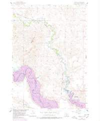
1956 Map of Wakpala
USGS Topo · Published 1979About this map
The Chicago Milwaukee St Paul and Pacific railroad forms the structural spine of this landscape within the Standing Rock Indian Reservation, running parallel to the winding course of Oak Creek. The settlement of Wakpala serves as a central hub, flanked by the St Bedes Cem and the St Elizabeth Mission Home. Significant topographical changes are documented here through the 1970s revisions, particularly the emergence of Lake Oahe Grand River, which dominates the western and southern reaches of the quadrangle. This inundation reshaped the confluence where Deep Bank Creek meets the river valley, reflecting the dramatic transformation of the Missouri River Basin during the mid-20th century. Away from the water, the terrain is marked by distinctive landmarks like Rattlesnake Butte, illustrating the transition from creek-side settlements to the high plains.
Find a feature on this map
13 named features on this map. Tap any name to fly to it.
Don’t see what you’re looking for? This feature index may not catch every label — zoom into the map to look around manually.
Map Details
Editions of this 1956 Wakpala Map
2 editions found
Other maps of this area

1953 · McIntosh
USGS Topo · 1:250,000

1956 · Wakpala NW
USGS Topo · 1:24,000

1956 · Wakpala SE
USGS Topo · 1:24,000

1956 · Wakpala SW
USGS Topo · 1:24,000

1956 · Wakpala
USGS Topo · 1:24,000

1958 · McIntosh
USGS Topo · 1:250,000

1966 · Mahto
USGS Topo · 1:24,000

1966 · Kenel
USGS Topo · 1:24,000

1966 · Kline Buttes
USGS Topo · 1:24,000

1967 · Mobridge NW
USGS Topo · 1:24,000