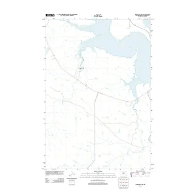
2012 Map of Wakpala SE
USGS Topo · Published 2012About this map
Lake Oahe dominates the eastern and northern reaches of this landscape, its complex, finger-like shoreline defining the boundary of Corson County. This 2012 survey captures the hydrology of the Missouri River reservoir system, where the rising waters have submerged the lower reaches of major tributaries. Both Snake Creek and Claymore Creek are shown as they transition from narrow prairie streams into broad, flooded inlets of the main reservoir. The map documents a sparsely populated region of South Dakota characterized by high-elevation contours and a minimal road network, reflecting the geographic isolation and specialized land use common to the lands surrounding the Oahe Dam project. Small seasonal watercourses like Snake Creek feed into the larger system, highlighting the drainage patterns of the northern plains.
Find a feature on this map
4 named features on this map. Tap any name to fly to it.
Don’t see what you’re looking for? This feature index may not catch every label — zoom into the map to look around manually.
Map Details
Editions of this 2012 Wakpala SE Map
This is the sole edition of this map. No revisions or reprints were ever made.
Other maps of this area

1953 · McIntosh
USGS Topo · 1:250,000

1956 · Wakpala NW
USGS Topo · 1:24,000

1956 · Wakpala SE
USGS Topo · 1:24,000

1956 · Wakpala SW
USGS Topo · 1:24,000

1956 · Wakpala
USGS Topo · 1:24,000

1958 · McIntosh
USGS Topo · 1:250,000

1967 · Mobridge NW
USGS Topo · 1:24,000

1967 · Mobridge
USGS Topo · 1:24,000

1968 · Moreau NW
USGS Topo · 1:24,000

1975 · Laundreaux Butte
USGS Topo · 1:24,000