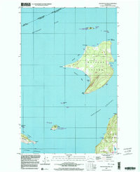
1997 Map of Waldron Island
USGS Topo · Published 2003About this map
Waldron Island sits at the northern edge of the archipelago, bounded by Boundary Pass and President Channel. This 1997 topographic study shows the island’s mix of dense woodland and cleared lands, with a small settlement at Waldron near the Cowlitz Bay shoreline. The landscape is marked by the presence of protected areas, including the San Juan Islands National Wildlife Refuge and San Juan Wilderness, which encompass smaller satellite landmasses like Skipjack Island and Flattop Island.
Find a feature on this map
46 named features on this map. Tap any name to fly to it.
Don’t see what you’re looking for? This feature index may not catch every label — zoom into the map to look around manually.
Map Details
Editions of this 1997 Waldron Island Map
This is the sole edition of this map. No revisions or reprints were ever made.
Other maps of this area

1943 · Orcas Island
USGS Topo · 1:62,500

1953 · Stuart Island
USGS Topo · 1:24,000

1954 · Roche Harbor
USGS Topo · 1:24,000

1954 · Waldron Island
USGS Topo · 1:24,000

1954 · Friday Harbor
USGS Topo · 1:24,000

1957 · Orcas Island
USGS Topo · 1:62,500

1957 · Victoria
USGS Topo · 1:250,000

1973 · Sucia Island
USGS Topo · 1:24,000

1973 · Shaw Island
USGS Topo · 1:24,000

1975 · Bellingham
USGS Topo · 1:100,000