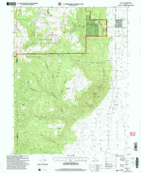
2001 Map of Wales
USGS Topo · Published 2004About this map
Wales sits at the foot of the massive Pitch Mountain range, serving as a gateway between the agricultural Sanpete Valley and the high timber of the Uinta National Forest. This landscape is defined by the sharp transition from the irrigated valley floor, where the San Pitch River flows, to the deeply incised canyons of the Sanpete Ranger District. The terrain is marked by numerous family and descriptive landmarks such as Axhandle Canyon, Magistrate Canyon, and Horse Mountain.
Find a feature on this map
42 named features on this map. Tap any name to fly to it.
Don’t see what you’re looking for? This feature index may not catch every label — zoom into the map to look around manually.
Map Details
Editions of this 2001 Wales Map
This is the sole edition of this map. No revisions or reprints were ever made.
Other maps of this area

1885 · Manti
USGS Topo · 1:250,000

1895 · Manti
USGS Topo · 1:250,000

1951 · Moroni
USGS Topo · 1:62,500

1951 · Nephi
USGS Topo · 1:62,500

1956 · Price
USGS Topo · 1:250,000

1960 · Price
USGS Topo · 1:250,000

1962 · Price
USGS Topo · 1:250,000

1965 · Chriss Canyon
USGS Topo · 1:24,000

1965 · Hells Kitchen Canyon SE
USGS Topo · 1:24,000

1965 · Manti
USGS Topo · 1:24,000