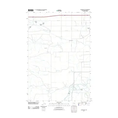
2011 Map of Walker Hill
USGS Topo · Published 2011About this map
Bighorn River hydrology and ranching infrastructure dominate this landscape south of Hardin. The terrain is shaped by a complex system of water management, including the Two Leggins Canal, Big Horn Canal, and numerous private water storage features such as R Downs Number 10 Dam and R Downs Number 6 Dam. These canals and dams illustrate the essential role of irrigation in supporting the valley's agricultural economy. The topographic transition is marked by Walker Hill, providing a vantage point over the converging waters of Two Leggins Creek and Spring Creek. Further south, the river features Far West Island near the junction with Two Leggins Creek Rd, while the uplands are cut by distinct drainage patterns like Williams Coulee and Crow Road Coulee. This map provides a detailed view of the road network connecting remote ranching outposts, including Old Us Hwy 87 and Maverick Rd, tracing the paths of local commerce and movement through the Big Horn basin.
Find a feature on this map
35 named features on this map. Tap any name to fly to it.
Don’t see what you’re looking for? This feature index may not catch every label — zoom into the map to look around manually.
Map Details
Editions of this 2011 Walker Hill Map
This is the sole edition of this map. No revisions or reprints were ever made.
Other maps of this area

1894 · Fort Custer
USGS Topo · 1:125,000

1954 · Hardin
USGS Topo · 1:250,000

1957 · Hardin
USGS Topo · 1:250,000

1958 · Hardin
USGS Topo · 1:250,000

1960 · Ninemile Point
USGS Topo · 1:24,000

1960 · Chimney Creek
USGS Topo · 1:24,000

1960 · Walker Hill
USGS Topo · 1:24,000

1960 · Hardin
USGS Topo · 1:24,000
1960 · Prante Ranch
USGS Topo · 1:24,000

1960 · Hardin SW
USGS Topo · 1:24,000