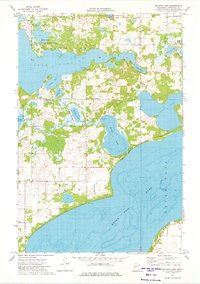
1973 Map of Walker Lake
USGS Topo · Published 1975About this map
Otter Tail Lake and its northern neighbors dominate this early 1970s landscape, reflecting a region defined by complex shorelines and extensive conservation efforts. The area's focus on habitat preservation is evident through several large preserves, including the Dead Lake State Wildlife Management Area and the Davies State Wildlife Management Area. Small lakeside communities and seasonal settlements are scattered throughout, with Amor situated near the southwest corner and Basswood positioned centrally. Local infrastructure of the era includes a Landing Strip and Oakwood Cem, alongside numerous access points like the Boat Ramp on Walker Lake. The winding Dead River connects several of these bodies of water, illustrating the intricate drainage patterns that characterize this part of Minnesota's lake country before more modern suburban expansion.
Find a feature on this map
27 named features on this map. Tap any name to fly to it.
Don’t see what you’re looking for? This feature index may not catch every label — zoom into the map to look around manually.
Map Details
Editions of this 1973 Walker Lake Map
This is the sole edition of this map. No revisions or reprints were ever made.
Other maps of this area

1912 · Vergas
USGS Topo · 1:62,500

1912 · Battle Lake
USGS Topo · 1:62,500

1914 · Battle Lake
USGS Topo · 1:62,500

1915 · Underwood
USGS Topo · 1:62,500

1915 · Perham
USGS Topo · 1:62,500

1915 · Vergas
USGS Topo · 1:62,500

1953 · Brainerd
USGS Topo · 1:250,000

1957 · Brainerd
USGS Topo · 1:250,000

1958 · Brainerd
USGS Topo · 1:250,000

1965 · Brainerd
USGS Topo · 1:250,000