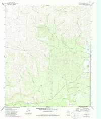
1972 Map of Wallace Draw
USGS Topo · Published 1987About this map
The Middle Concho River winds through the southern portion of this Irion County landscape, providing a critical water source in a region defined by its intermittent drainage patterns. The map detail shows the convergence of several significant landforms, including the prominent Wallace Draw and the seasonally dry bed of Dry Creek. Settlement in this era is centered on the expansive Sugg Ranch, reflecting the large-scale ranching operations that have long anchored the local economy.
Find a feature on this map
9 named features on this map. Tap any name to fly to it.
Don’t see what you’re looking for? This feature index may not catch every label — zoom into the map to look around manually.
Map Details
Editions of this 1972 Wallace Draw Map
2 editions found
Other maps of this area

1895 · Sherwood
USGS Topo · 1:125,000

1921 · Ketchum Mountain
USGS Topo · 1:62,500

1923 · Ketchum Mountain
USGS Topo · 1:62,500

1954 · San Angelo
USGS Topo · 1:250,000

1958 · San Angelo
USGS Topo · 1:250,000

1965 · San Angelo
USGS Topo · 1:250,000

1972 · Arden
USGS Topo · 1:24,000

1972 · Wallace Draw
USGS Topo · 1:24,000
1972 · Mertzon SW
USGS Topo · 1:24,000

1972 · Dog Creek SW
USGS Topo · 1:24,000