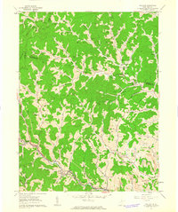
1960 Map of Wallace
USGS Topo · Published 1963About this map
Deeply incised hollows and a dense network of oil wells define this landscape at the junction of Harrison, Marion, and Wetzel counties. The Baltimore and Ohio railroad follows the winding course of Little Tenmile Creek, connecting the settlements of Wallace, Brown, and Dola. In the southeastern corner, the transition from subsistence farming to industrial extraction is evident through several Strip Mine sites and mine air shafts near Jimtown. Local genealogy is well-preserved through numerous family-named landmarks like Boggess Cem, Hildreth Cem, and Marsh Cem. Small communities such as Grangeville, Joetown, and Quaker are linked by narrow roads following ridge lines and creek beds, while Elizabeth Mason Memorial Park serves as a prominent local landmark near Grangeville Sch.
Find a feature on this map
79 named features on this map. Tap any name to fly to it.
Don’t see what you’re looking for? This feature index may not catch every label — zoom into the map to look around manually.
Map Details
Editions of this 1960 Wallace Map
2 editions found
Other maps of this area

1902 · Clarksburg
USGS Topo · 1:62,500

1903 · Littleton
USGS Topo · 1:62,500

1905 · Mannington
USGS Topo · 1:62,500

1905 · Centerpoint
USGS Topo · 1:62,500

1905 · Littleton
USGS Topo · 1:62,500

1910 · Clarksburg
USGS Topo · 1:62,500

1923 · Mannington
USGS Topo · 1:62,500

1923 · Clarksburg
USGS Topo · 1:62,500

1924 · Centerpoint
USGS Topo · 1:62,500

1924 · Littleton
USGS Topo · 1:62,500