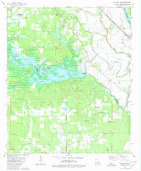
1980 Map of Wallace Lake
USGS Topo · Published 1980About this map
Wallace Lake dominates this 1980 survey, where the Wallace Lake Dam and Spillway Elevation 158 regulate the waters at the junction of Caddo and De Soto Parishes. The map captures a landscape defined by its riparian boundaries and transportation corridors, including the Kansas City Southern and Missouri Pacific railroads that flank the basin. Small landings like DeBroeck Landing and Palmer Landing suggest a lifestyle oriented toward the water's edge, while inland areas show a high density of country churches and community nodes.
Find a feature on this map
54 named features on this map. Tap any name to fly to it.
Don’t see what you’re looking for? This feature index may not catch every label — zoom into the map to look around manually.
Map Details
Editions of this 1980 Wallace Lake Map
2 editions found
Other maps of this area

1938 · Arnsberg
USGS Topo · 1:31,680

1941 · Forbing
USGS Topo · 1:31,680

1945 · Grand Cane
USGS Topo · 1:62,500

1945 · Greenwood
USGS Topo · 1:62,500

1945 · Mansfield
USGS Topo · 1:62,500

1947 · Mansfield
USGS Topo · 1:62,500

1948 · Caspiana
USGS Topo · 1:62,500

1955 · Shreveport
USGS Topo · 1:250,000

1955 · Shreveport East
USGS Topo · 1:24,000

1955 · Caspiana
USGS Topo · 1:62,500