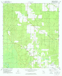
1978 Map of Wallace
USGS Topo · Published 1978About this map
The community of Wallace serves as a central hub in this late 1970s landscape, where small-scale agriculture and extractive industries like sandpits and claypits meet the expansive U S Naval Reservation Spencer Field in the southeast. This survey details a dense network of watercourses including Tenmile Creek, Sevenmile Creek, and Milligan Creek that feed into the White River. The river's lower reach is characterized by marshy features such as Brosnaham Island and the isolated Burnt Cypress Lake. Cultural landmarks are prominently featured, notably Elizabeth Chapel and its adjacent cemetery, providing valuable data for genealogical research. The presence of a Lookout Tower, a gaging station, and multiple radio towers, including Radio Tower (WXBM), indicates a landscape increasingly integrated with modern communication and resource management infrastructure during this era.
Find a feature on this map
32 named features on this map. Tap any name to fly to it.
Don’t see what you’re looking for? This feature index may not catch every label — zoom into the map to look around manually.
Map Details
Editions of this 1978 Wallace Map
2 editions found
Other maps of this area

1920 · Milton
USGS Topo · 1:62,500

1921 · Muscogee
USGS Topo · 1:62,500

1941 · Muscogee
USGS Topo · 1:62,500

1941 · Milton
USGS Topo · 1:62,500

1941 · Century
USGS Topo · 1:62,500

1943 · Muscogee
USGS Topo · 1:62,500

1943 · Century
USGS Topo · 1:62,500

1943 · Milton
USGS Topo · 1:62,500

1943 · Jay
USGS Topo · 1:62,500
1944 · Floridatown
USGS Topo · 1:25,000