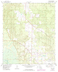
1978 Map of Wallace
USGS Topo · Published 1987About this map
Wallace serves as the central point of this West Florida survey, situated along a north-south roadway in Santa Rosa County. The landscape is defined by the heavy drainage patterns of Tenmile Creek and Sevenmile Creek, which flow toward the southern wetlands near White River. Notable for its naval aviation history, the area includes portions of US Naval Res OLF Pace and US Naval Reservation OLF Spencer, reflecting the military presence that shaped the local geography in the late 1970s.
Find a feature on this map
37 named features on this map. Tap any name to fly to it.
Don’t see what you’re looking for? This feature index may not catch every label — zoom into the map to look around manually.
Map Details
Editions of this 1978 Wallace Map
2 editions found
Other maps of this area

1920 · Milton
USGS Topo · 1:62,500

1921 · Muscogee
USGS Topo · 1:62,500

1941 · Muscogee
USGS Topo · 1:62,500

1941 · Milton
USGS Topo · 1:62,500

1941 · Century
USGS Topo · 1:62,500

1943 · Muscogee
USGS Topo · 1:62,500

1943 · Century
USGS Topo · 1:62,500

1943 · Milton
USGS Topo · 1:62,500

1943 · Jay
USGS Topo · 1:62,500
1944 · Floridatown
USGS Topo · 1:25,000