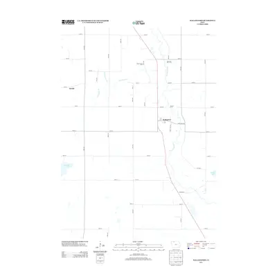
2013 Map of Wallingford
USGS Topo · Published 2013About this map
The Des Moines River winds through the heart of this Emmet County landscape, defining the agricultural character of the region. The small community of Wallingford serves as a central hub, situated along the primary north-south roadway and the river's eastern bank. To the north, the Emmet County Home and River View Golf Course sit near the settlement of Highlake, while the western portion of the map is dominated by the expansive Twelvemile Lake and the hamlet of Raleigh. The terrain is significantly managed for drainage, as evidenced by the engineered path of Ditch Number 151 crossing the prairie. This 2013 survey provides a clear view of how modern rural infrastructure, including a dense grid of numbered roads like Saint James Ave and Burr Oak Rd, integrates with the natural water bodies and conservation areas like Peterson Access.
Find a feature on this map
32 named features on this map. Tap any name to fly to it.
Don’t see what you’re looking for? This feature index may not catch every label — zoom into the map to look around manually.
Map Details
Editions of this 2013 Wallingford Map
This is the sole edition of this map. No revisions or reprints were ever made.
Other maps of this area

1954 · Fairmont
USGS Topo · 1:250,000

1958 · Fairmont
USGS Topo · 1:250,000

1972 · Graettinger West
USGS Topo · 1:24,000

1972 · Terril
USGS Topo · 1:24,000

1972 · Wallingford
USGS Topo · 1:24,000

1972 · Estherville
USGS Topo · 1:24,000
1972 · Ruthven
USGS Topo · 1:24,000
1972 · Superior
USGS Topo · 1:24,000

1980 · Ingham Lake
USGS Topo · 1:24,000

1980 · Gruver
USGS Topo · 1:24,000