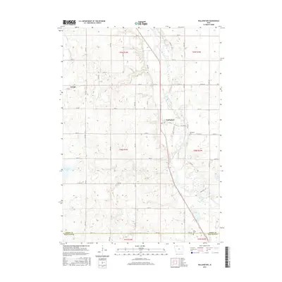
2015 Map of Wallingford
USGS Topo · Published 2015About this map
The Des Moines River winds through the eastern portion of this Emmet County landscape, providing a natural north-south axis for the community of Wallingford. This modern survey reveals a highly organized agricultural grid, punctuated by vital water resources like Twelvemile Lake and Bur Oak Lake. The engineering of the land is evident in features such as Ditch Number 151, which helps manage the drainage of this prairie-pothole region for farming. Genealogists will find significant value in the documentation of local burial sites, including Wallingford Cem, Saint Jacobs Cem, and the City Cem, all positioned near the river valley or established section lines. The small settlement of Raleigh sits in the northwest, connected to the larger region by an extensive network of county roads like Co Hwy A33 and Co Hwy B.
Find a feature on this map
32 named features on this map. Tap any name to fly to it.
Don’t see what you’re looking for? This feature index may not catch every label — zoom into the map to look around manually.
Map Details
Editions of this 2015 Wallingford Map
This is the sole edition of this map. No revisions or reprints were ever made.
Other maps of this area

1954 · Fairmont
USGS Topo · 1:250,000

1958 · Fairmont
USGS Topo · 1:250,000

1972 · Graettinger West
USGS Topo · 1:24,000

1972 · Terril
USGS Topo · 1:24,000

1972 · Wallingford
USGS Topo · 1:24,000

1972 · Estherville
USGS Topo · 1:24,000
1972 · Ruthven
USGS Topo · 1:24,000
1972 · Superior
USGS Topo · 1:24,000

1980 · Ingham Lake
USGS Topo · 1:24,000

1980 · Gruver
USGS Topo · 1:24,000