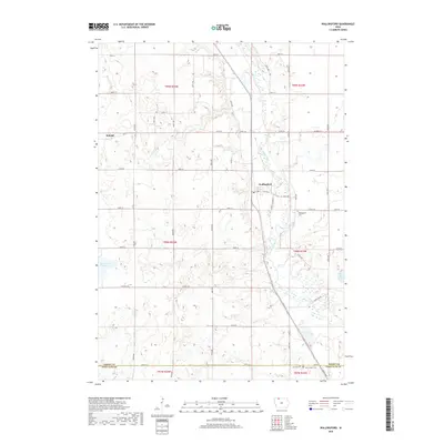
2018 Map of Wallingford
USGS Topo · Published 2018About this map
The Des Moines River winds through the eastern portion of this northern Iowa landscape, defining the character of the river valley near Wallingford. To the west, the terrain transitions into a glaciated prairie upland marked by natural depressions and modern agricultural engineering, seen in the channelized Ditch Number 151 and the large expanse of Twelvemile Lake. The settlement at Raleigh sits on the western edge of the quadrangle, while Wallingford serves as a central hub near the river. This survey captures the rural layout of the region, emphasizing the importance of local heritage through the documentation of Wallingford Cem, Saint Jacobs Cem, and City Cem. The southern boundary follows the Emmet Co Palo Alto Co line, illustrating the intersection of county jurisdictions in this heavily farmed river basin.
Find a feature on this map
31 named features on this map. Tap any name to fly to it.
Don’t see what you’re looking for? This feature index may not catch every label — zoom into the map to look around manually.
Map Details
Editions of this 2018 Wallingford Map
This is the sole edition of this map. No revisions or reprints were ever made.
Other maps of this area

1954 · Fairmont
USGS Topo · 1:250,000

1958 · Fairmont
USGS Topo · 1:250,000

1972 · Graettinger West
USGS Topo · 1:24,000

1972 · Terril
USGS Topo · 1:24,000

1972 · Wallingford
USGS Topo · 1:24,000

1972 · Estherville
USGS Topo · 1:24,000
1972 · Ruthven
USGS Topo · 1:24,000
1972 · Superior
USGS Topo · 1:24,000

1980 · Ingham Lake
USGS Topo · 1:24,000

1980 · Gruver
USGS Topo · 1:24,000