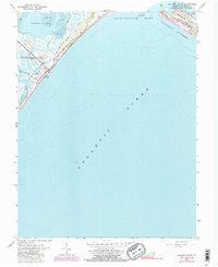
1965 Map of Wallops Island
USGS Topo · Published 1991About this map
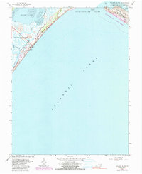
Wallops Island serves as a critical junction for aerospace operations and coastal conservation on the Eastern Shore. By the mid-1960s, the Wallops Flight Center (NASA) had established a significant presence on the barrier island, marked by a network of Launch Pads, Radio Towers, and a Weather Station. This technological footprint contrasts with the preserved natural landscape of the Assateague Island National Seashore and the Chincoteague National Wildlife Refuge located across the Chincoteague Inlet. The map details a complex hydrologic environment where Bogues Bay and Tidal Flats meet the Atlantic Ocean. Inland waterways like Island Hole Narrows and Pre Hammock Creek navigate the marshy terrain, illustrating the delicate balance between high-tech infrastructure and the shifting sands of Fishing Point.
Find a feature on this map
25 named features on this map. Tap any name to fly to it.
Don’t see what you’re looking for? This feature index may not catch every label — zoom into the map to look around manually.
Map Details
Editions of this 1965 Wallops Island Map
5 editions found
Other maps of this area

1931 · Accomac
USGS Topo · 1:48,000

1935 · Accomac
USGS Topo · 1:62,500

1942 · Chincoteague East
USGS Topo · 1:24,000

1942 · Mappsville
USGS Topo · 1:24,000

1942 · Wallops Island
USGS Topo · 1:24,000

1943 · Mappsville
USGS Topo · 1:31,680

1943 · Chincoteague West
USGS Topo · 1:31,680
1943 · Hallwood
USGS Topo · 1:31,680

1943 · Wallops Island
USGS Topo · 1:31,680
1943 · Chincoteague East
USGS Topo · 1:31,680