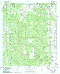
1978 Map of Walnut Hill
USGS Topo · Published 1985About this map
The Alabama-Florida state line defines the northern boundary of this landscape, where the Perdido River serves as the winding natural border between Baldwin and Escambia counties. The area is characterized by a dense network of creek drainages, including Brushy Creek and Rocky Creek, which flow southward through the undulating terrain. Settled communities are concentrated around Walnut Hill and the smaller Pineville to the west. Local genealogy is well-documented through several established burial grounds, such as Dutch Cem, Halls Fork Cem, and Antioch Cem, which sits adjacent to Antioch Ch. Industrial and transportation markers include a Claypit near the state line, a Landing Strip in the eastern section, and a Pipeline cutting across the southern reaches, reflecting the mid-20th-century development of this rural borderland.
Find a feature on this map
25 named features on this map. Tap any name to fly to it.
Don’t see what you’re looking for? This feature index may not catch every label — zoom into the map to look around manually.
Map Details
Editions of this 1978 Walnut Hill Map
3 editions found
Other maps of this area

1941 · Century
USGS Topo · 1:62,500

1942 · Perdido
USGS Topo · 1:62,500

1942 · Dyas
USGS Topo · 1:62,500

1943 · Century
USGS Topo · 1:62,500

1944 · Dyas
USGS Topo · 1:62,500

1944 · Perdido
USGS Topo · 1:62,500

1953 · Andalusia
USGS Topo · 1:250,000

1957 · Andalusia
USGS Topo · 1:250,000

1957 · Pensacola
USGS Topo · 1:250,000

1959 · Pensacola
USGS Topo · 1:250,000