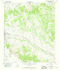
1966 Map of Walnut Springs East
USGS Topo · Published 1989About this map
Walnut Springs serves as the primary hub of this 1960s landscape, situated where the valley of Steele Creek meets several intersecting transportation lines. The map documents the remnants of a local rail history, with a line marked Abandoned cutting through the center of town near Katy Park and the Athletic Field. This era of transition is reflected in the land use, where traditional rural markers like Oak Grove Cem and Willow Springs Ch sit alongside modern utility infrastructure, including a Substation, several Pipelines, and a Radio Tower.
Find a feature on this map
26 named features on this map. Tap any name to fly to it.
Don’t see what you’re looking for? This feature index may not catch every label — zoom into the map to look around manually.
Map Details
Editions of this 1966 Walnut Springs East Map
This is the sole edition of this map. No revisions or reprints were ever made.
Other maps of this area

1888 · Meridian
USGS Topo · 1:125,000

1889 · Granbury
USGS Topo · 1:125,000

1894 · Meridian
USGS Topo · 1:125,000

1924 · Granbury 4-a
USGS Topo · 1:48,000

1931 · Morgan
USGS Topo · 1:62,500

1954 · Dallas
USGS Topo · 1:250,000

1954 · Waco
USGS Topo · 1:250,000

1955 · Waco
USGS Topo · 1:250,000

1955 · Meridian
USGS Topo · 1:24,000
1955 · Pilot Knob
USGS Topo · 1:24,000