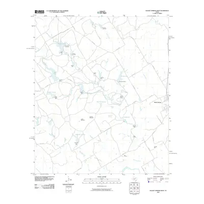
2010 Map of Walnut Springs West
USGS Topo · Published 2010About this map
Walnut Springs anchors the eastern edge of this landscape, where the prairie of Bosque County meets the controlled waters of the East Bosque River and North Bosque River. In the early 21st century, this area is defined by the extensive operations of the Flat Top Ranch, which manages numerous water features including East Flat Top Lake and South Flat Top Lake. The terrain is punctuated by distinctive rises such as Flat Top Mountain, Cedar Mountain, and Dinner Hill, providing natural orientation points across the ranch lands. Local heritage is preserved at the Fulton Cemetery and Barry Cemetery, located near the southern bends of the East Bosque. A complex network of water management is visible through labels like Mustang Lake Dam, Beecherl Dam, and the Irrigation Dam, illustrating how the ranching economy has historically harnessed the local drainage systems of Mustang Creek and Hester Branch.
Find a feature on this map
54 named features on this map. Tap any name to fly to it.
Don’t see what you’re looking for? This feature index may not catch every label — zoom into the map to look around manually.
Map Details
Editions of this 2010 Walnut Springs West Map
This is the sole edition of this map. No revisions or reprints were ever made.
Other maps of this area

1888 · Meridian
USGS Topo · 1:125,000

1889 · Granbury
USGS Topo · 1:125,000

1894 · Meridian
USGS Topo · 1:125,000

1931 · Morgan
USGS Topo · 1:62,500

1954 · Dallas
USGS Topo · 1:250,000

1954 · Waco
USGS Topo · 1:250,000

1955 · Waco
USGS Topo · 1:250,000

1955 · Meridian
USGS Topo · 1:24,000
1956 · Spring Creek Gap
USGS Topo · 1:24,000
1956 · Clifton
USGS Topo · 1:62,500