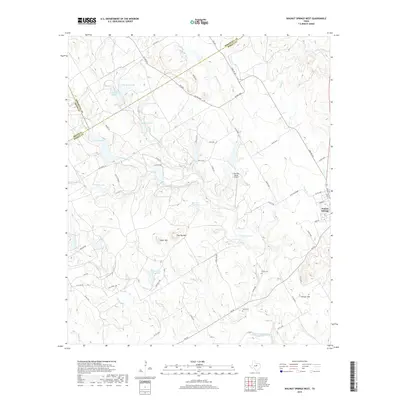
2019 Map of Walnut Springs West
USGS Topo · Published 2019About this map
Walnut Springs sits at the eastern edge of this landscape where the Bosque, Somervell, and Erath county lines converge. The terrain is defined by a dense network of upland drainage, where the North Bosque River and the E Bosque River are fed by numerous seasonal branches and creeks including Mustang Cr and Steele Cr. Local landmarks such as Flat Top Mtn and Cedar Mtn overlook a series of private ranch water features, including Ownsby Lake, Polnac Lake, and Flag Br Lake.
Find a feature on this map
67 named features on this map. Tap any name to fly to it.
Don’t see what you’re looking for? This feature index may not catch every label — zoom into the map to look around manually.
Map Details
Editions of this 2019 Walnut Springs West Map
This is the sole edition of this map. No revisions or reprints were ever made.
Other maps of this area

1888 · Meridian
USGS Topo · 1:125,000

1889 · Granbury
USGS Topo · 1:125,000

1894 · Meridian
USGS Topo · 1:125,000

1931 · Morgan
USGS Topo · 1:62,500

1954 · Dallas
USGS Topo · 1:250,000

1954 · Waco
USGS Topo · 1:250,000

1955 · Waco
USGS Topo · 1:250,000

1955 · Meridian
USGS Topo · 1:24,000
1956 · Spring Creek Gap
USGS Topo · 1:24,000
1956 · Clifton
USGS Topo · 1:62,500