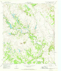
1966 Map of Walnut Springs West
USGS Topo · Published 1968About this map
Flat Top Ranch dominates the landscape of the northern Bosque country in the mid-1960s, showing an extensive network of private water management and aviation infrastructure. The terrain is defined by the convergence of the East Bosque River and the North Bosque River, with numerous artificial impoundments like Irrigation Lake and Old Lake supporting the ranching operations. To the east, the settlement of Walnut Springs sits along a rail corridor marked as abandoned, indicating the shift away from the old railroad economy that once sustained these small Texas towns.
Find a feature on this map
38 named features on this map. Tap any name to fly to it.
Don’t see what you’re looking for? This feature index may not catch every label — zoom into the map to look around manually.
Map Details
Editions of this 1966 Walnut Springs West Map
This is the sole edition of this map. No revisions or reprints were ever made.
Other maps of this area

1888 · Meridian
USGS Topo · 1:125,000

1889 · Granbury
USGS Topo · 1:125,000

1894 · Meridian
USGS Topo · 1:125,000

1931 · Morgan
USGS Topo · 1:62,500

1954 · Dallas
USGS Topo · 1:250,000

1954 · Waco
USGS Topo · 1:250,000

1955 · Waco
USGS Topo · 1:250,000

1955 · Meridian
USGS Topo · 1:24,000
1956 · Spring Creek Gap
USGS Topo · 1:24,000
1956 · Clifton
USGS Topo · 1:62,500