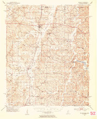
1951 Map of Walnut
USGS Topo · Published 1953About this map
Walnut and Chalybeate anchor this rural landscape along the Tennessee-Mississippi border during the early 1950s. The region is defined by a dense network of country roads, cemeteries, and small churches such as Piney Wood Ch and New Salem Ch, which served as the social centers for outlying farmsteads. The Gulf Mobile and Ohio railroad runs north-south through the terrain, connecting settlements like Tiplersville and Falkner and providing critical infrastructure via stops at Cliff Siding and Howell Siding.
Find a feature on this map
118 named features on this map. Tap any name to fly to it.
Don’t see what you’re looking for? This feature index may not catch every label — zoom into the map to look around manually.
Map Details
Editions of this 1951 Walnut Map
4 editions found
Other maps of this area

1921 · Booneville
USGS Topo · 1:48,000

1922 · Booneville
USGS Topo · 1:62,500

1950 · Ashland
USGS Topo · 1:62,500

1950 · Corinth
USGS Topo · 1:62,500

1950 · Pocahontas
USGS Topo · 1:24,000

1950 · Middleton
USGS Topo · 1:24,000

1951 · Middleton
USGS Topo · 1:24,000

1951 · Chewalla
USGS Topo · 1:24,000

1951 · Walnut
USGS Topo · 1:62,500

1952 · Pocahontas
USGS Topo · 1:24,000