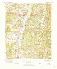
1951 Map of Walnut
USGS Topo · Published 1973About this map
The Gulf Mobile and Ohio railroad corridor serves as the primary north-south artery through this portion of Tippah County, connecting the towns of Walnut, Tiplersville, and Falkner. This 1951 field-checked survey highlights a landscape defined by the drainage systems of Muddy Creek and the Hatchie River, where many small rural communities like Chalybeate and Jonesboro are positioned along the ridges and valley floors. To the west, the Holly Springs National Forest occupies the more dissected terrain, while the eastern reaches toward the Alcorn County line are marked by numerous family-named landmarks and cemeteries. Genealogists will find a wealth of specific local data, from schools like the Ruckerville Sch and Oakland Sch to several remote burial grounds including Smyrna Cem and Old Mt Zion Cem, providing a clear view of the mid-century settlement patterns in Mississippi's northern hill country.
Find a feature on this map
102 named features on this map. Tap any name to fly to it.
Don’t see what you’re looking for? This feature index may not catch every label — zoom into the map to look around manually.
Map Details
Editions of this 1951 Walnut Map
4 editions found
Other maps of this area

1921 · Booneville
USGS Topo · 1:48,000

1922 · Booneville
USGS Topo · 1:62,500

1950 · Ashland
USGS Topo · 1:62,500

1950 · Corinth
USGS Topo · 1:62,500

1950 · Pocahontas
USGS Topo · 1:24,000

1950 · Middleton
USGS Topo · 1:24,000

1951 · Middleton
USGS Topo · 1:24,000

1951 · Chewalla
USGS Topo · 1:24,000

1951 · Walnut
USGS Topo · 1:62,500

1952 · Pocahontas
USGS Topo · 1:24,000